Horizontal Strata Manufacturer,Supplier and Exporter in India
Product Code : JA-AM-5967
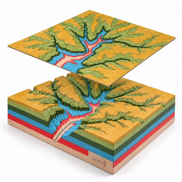
The Horizontal Strata model shows a stream cutting sideways and downwards into flat-lying rock layers, with weathering on the slopes above. The layers below the surface are shown in cross section. The model is about 300 x 200 x 100 mm, fixed to a stable baseboard, with a numbered key card for its features.
Specifications of the horizontal strata model
| Product code | JA-AM-5967 (order code kept from the earlier listing) |
|---|---|
| Shows | Lateral stream erosion and weathering of horizontal rock layers |
| Section | Underlying layers shown in cross section |
| Size | About 300 x 200 x 100 mm* |
| Baseboard | Stable baseboard, about 320 x 220 mm* |
| Key | Numbered key card, with a stratigraphic key* |
| Subject | Physical geography and geology |
| Manufacturer | JaincoLab, Ambala, India |
* Standard JaincoLab specification for new builds.
Using the horizontal strata model in geography lessons
- Oldest to youngest. Students number the layers from the bottom up and say which layer the stream is cutting into now.
- River at work. Compare the valley on the model with the river stages on the River in Action 3D Model. Then cut a small valley in sand on the Stream Table Kit.
- Rocks of the layers. Pass round samples from the Collection of 15 Sedimentary Rocks and discuss which of the rocks would wear away fastest on the valley sides.
- Map and section. Students sketch a plan view of the model with the layer boundaries, then draw a cross section along the valley.
Frequently Asked Questions
Which layer in a horizontal strata model is the oldest?
In undisturbed flat-lying strata the lowest layer is the oldest, and each layer above it is younger. This is the law of superposition. Students number the layers on the model from the bottom up and then name the layer the stream has reached last.
Why do the same rock layers appear on both sides of a valley?
The layers were laid down as continuous flat sheets before the stream cut through them. The valley removed the middle part, so the same sequence shows on both sides at the same heights. Matching the layers across the gap uses the idea of lateral continuity.
How do flat-lying layers show on a map of the valley?
Each boundary between flat layers stays at one height, so on a map it runs along the contour lines. Where the stream has cut a valley, the boundaries bend upstream into it, just as the contours do. Students can sketch this plan view from the model.
Is the horizontal strata model fixed to a base?
Yes. The standard build is fixed to a stable baseboard of about 320 x 220 mm, with a numbered key card and a stratigraphic key. It stands on a bench or in a display cabinet without extra support.
What should a geography department list for this model in a tender?
List a horizontal strata model showing lateral stream erosion and weathering, with the layers in cross section. Give the size as about 300 x 200 x 100 mm on a baseboard of about 320 x 220 mm. Add the numbered key card and the quantity needed.
Other geology and landform models
See the Geology Equipment range and more geography models from JaincoLab, a geography lab equipment manufacturer in India.
For a quotation, send the product name and the quantity you need through our contact page. For tender or project supply, see our tenders page.